

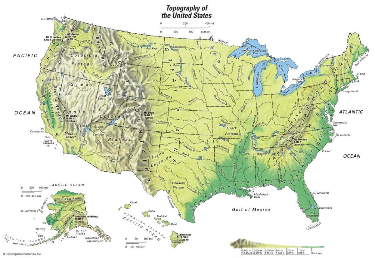
You can find on this page the USA geographical map to print and to download in PDF. The USA geographic map presents the topography, elevation, rivers, mountains, climate and physical features of USA in Americas.

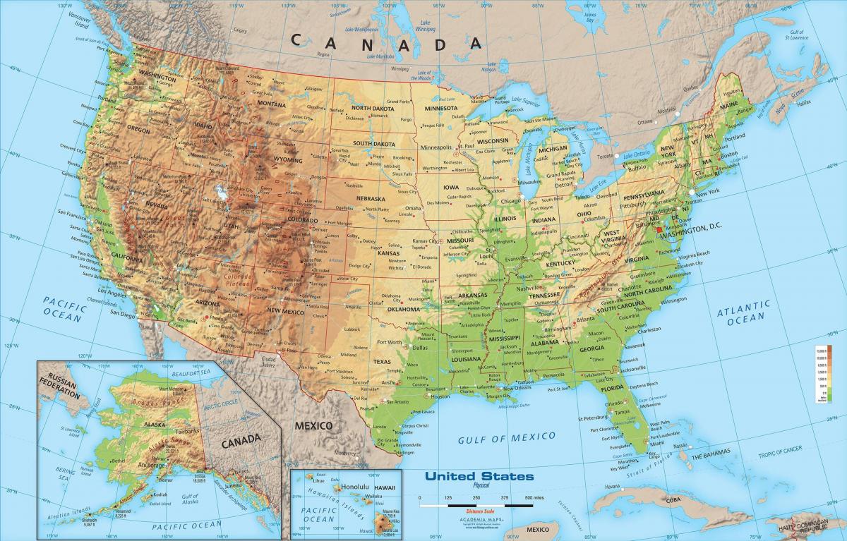
The USA physical map shows landform and geography of USA. This geographical map of USA will allow you to discover physical features of USA in Americas. The USA physical map is downloadable in PDF, printable and free.
The USA is a very diverse place politically and physically ranging from forest to desert and from plains to The Rocky Mountains as its mentioned in USA physical map. Although most of the USA land is forested, a significant percentage is desert; Mainly in the MidWest and parts of Alaska. Nevertheless, the USA is probably the most geographically diverse country in the world.
The Appalachian Mountains as you can see in USA physical map may be some of the oldest mountains on earth. The segmented chain of physical landforms cuts across the eastern side of North America, including U.S. states such as New York, Pennsylvania, Connecticut and Alabama. The highest range is the Blue Ridge Mountains, and the highest peak is at Mount Mitchell.
The Rocky Mountains as its shown in USA physical map are a mountain range that passes through the western states, such as Utah and Colorado. The Rockies are taller, steeper and craggier than the Appalachians because the western mountains are not old enough to have experienced the same amount of wearing by the elements. Yellowstone National Park and Royal Gorge are examples of the various tourist attractions that are set in the Rocky Mountains.
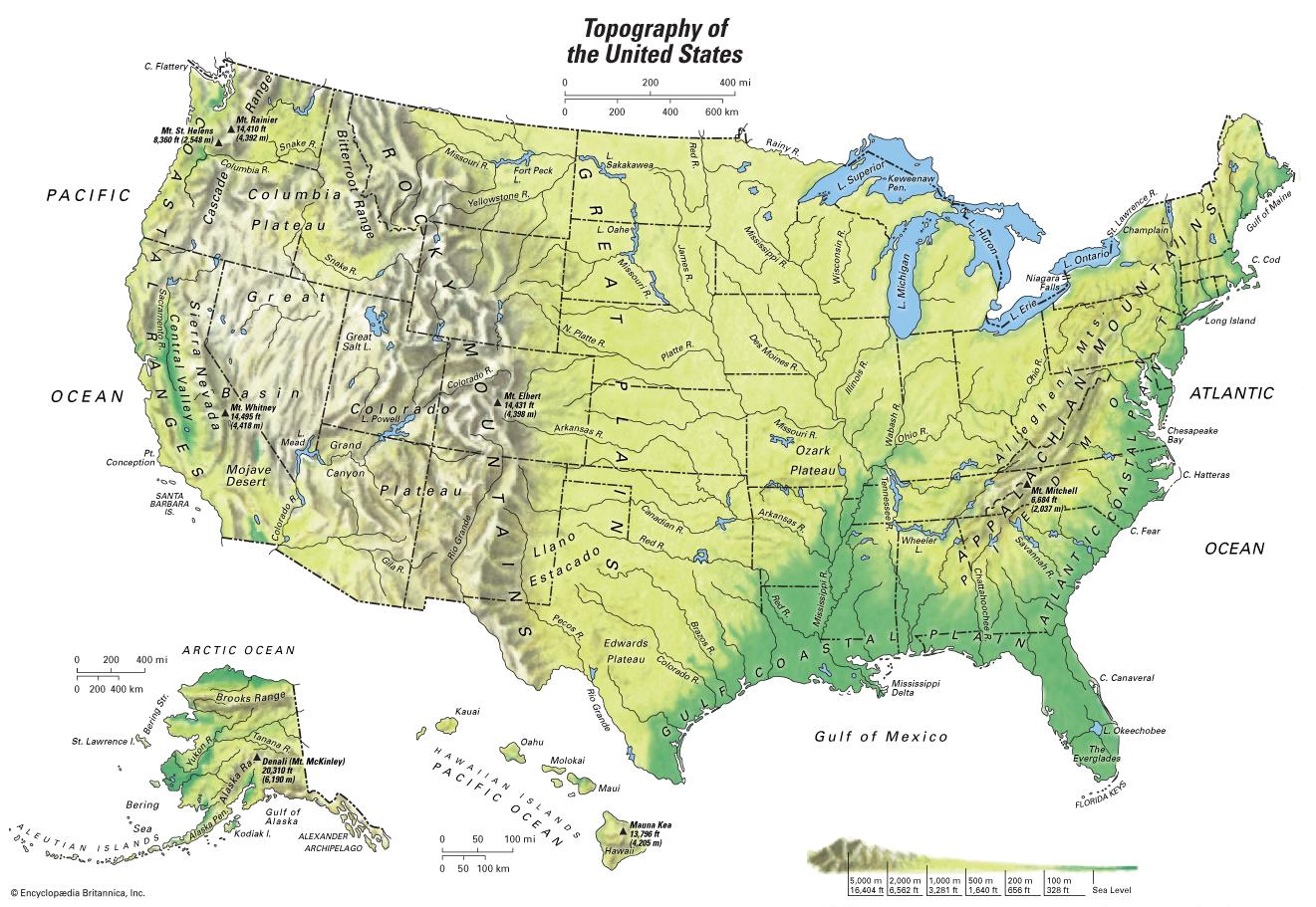
USA topographic map shows the physical features of USA. This topographical map of USA will allow you to discover landforms and geographical of USA in Americas. The USA topographic map is downloadable in PDF, printable and free.
In its broadest topographic outline, the continental USA comprises a large, central lowland—accounting for close to half its total area—bordered on the east and west by highlands as its shown in USA topographic map. The western highland area, which begins with the Rocky Mountains, is by far the more extensive of the two, accounting for about one-third of the total area of the country. The band of highlands on the east, which is lower and less extensive, consists of the Appalachian Mountains. The Mississippi River and its tributaries dominate the lowland in between, with the Great Lakes to the north. The western part of this lowland is known as the Great Plains. East and south of the Appalachian Mountains are coastal plains.
The eastern USA has a varied topography. A broad, flat coastal plain lines the Atlantic and Gulf shores from the Texas-Mexico border to New York City, and includes the Florida peninsula as its mentioned in USA topographic map. Areas further inland feature rolling hills and temperate forests. The southeast United States contain subtropical forests and, near the gulf coast, mangrove wetlands, especially in Florida. The generally low relief of the plains is broken in several places, most notably in the Ozark and Ouachita Mountains, which form the USA Interior Highlands, the only major mountainous region between the Rocky Mountains and the Appalachian Mountains.
Off the Atlantic coast, the USA continental shelf is more than 161 kilometers (100 miles) wide; beyond this, the ocean floor plunges to depths of more than 3.2 kilometers (2 miles) as you can see in USA topographic map. The continental shelf along most of the Pacific coast is quite narrow. Two major mountain ridges extend about 2,414 kilometers (1,500 miles) westward from the coast into the Pacific Ocean. Oceanic trenches line the southern shores of the Alaska Peninsula and the Aleutian Islands. The Aleutian Trench, at 7,620 meters (25,000 feet) below sea level, is the lowest point bordering North America.
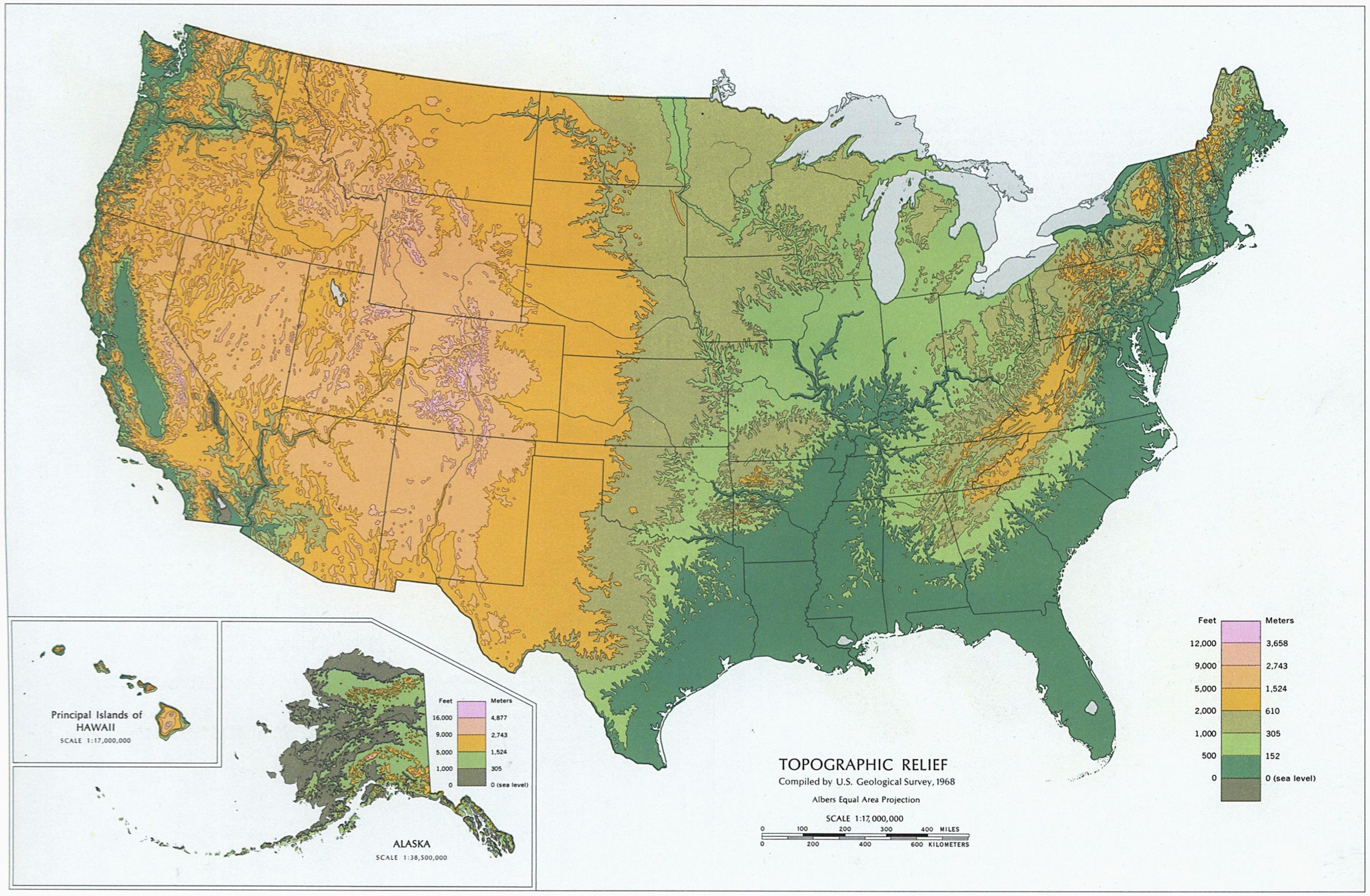
The USA elevation map shows the different altitudes of USA. This altitude map of USA will allow you to know where are the highest and lowest regions of USA in Americas. The USA elevation map is downloadable in PDF, printable and free.
This map shows the terrain (a geographic area) of the USA. Higher elevations are shown in brown and tan, like the Rocky Mountains and Pacific Coast Ranges of the western United States. In the eastern USA, the Appalachian Mountains trend from New England down to Alabama. The Sierra Nevada and Cascade mountain ranges run close to the Pacific coast, both ranges reaching altitudes higher than 14,000 feet (4,300 m). The lowest and highest points in the contiguous USA are in the state of California, and only about 84 miles (135 km) apart. At an elevation of 20,310 feet (6,190.5 m), Alaska Denali (Mount McKinley) is the highest peak in the country and North America.
Death Valley is a desert valley located in Eastern California. Situated within the Mojave Desert, it features the lowest, driest, and hottest locations in North America. Badwater, a basin located in Death Valley, is the specific location (36° 15' N 116° 49.5' W) of the lowest elevation in North America at 282 feet (86 m) below sea level as its mentioned in USA elevation map. This point is only 84.6 miles (136.2 km) ESE of Mount Whitney, the highest point in the contiguous USA with an elevation of 14,505 feet (4,421 m).
Mount McKinley, or Denali (Koyukon Athabaskan for "The High One", Dghelaayce’e in Ahtna), in Alaska, is the highest mountain peak in the USA and in North America, with a summit elevation of 20,320 feet (6,194 m) above sea level as you can see in USA elevation map. Measured base-to-peak, it is the tallest mountain on land. Measured by topographic prominence, it is the third most prominent peak in the world after Mount Everest and Aconcagua. It is the centerpiece of Denali National Park and Preserve.

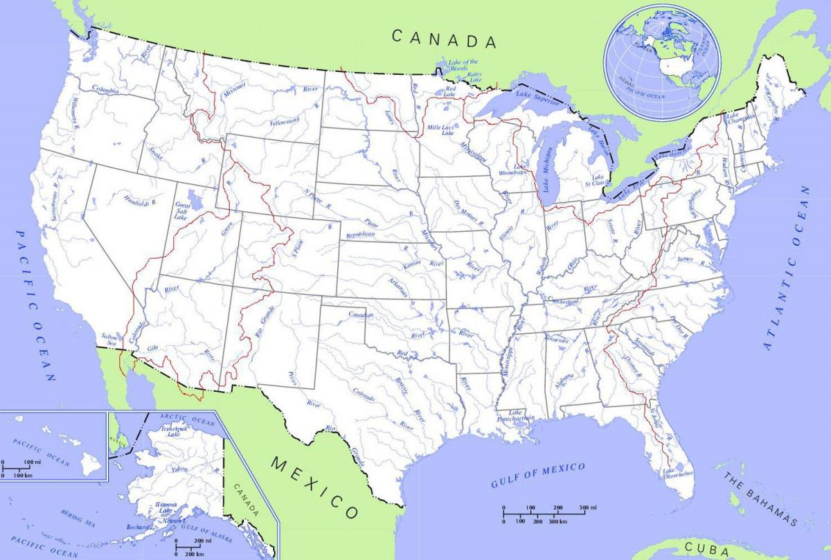
The rivers in USA map shows the principal rivers with their names of USA. The rivers map of USA will allow you to find the main rivers which flow in and through USA in Americas. The USA rivers map is downloadable in PDF, printable and free.
With few exceptions, the rivers to the east of the USA Continental Divide drain into the Atlantic Ocean and the Gulf of Mexico; those to the west drain into the Pacific. There are many short rivers east of the Appalachian Mountains that flow into the Atlantic; chief among them is the Hudson River as its shown in USA rivers map. Even the longest of these waterways flows for only several hundred miles, however. The Missouri is the longest river in the USA, as well as the longest on the continent of North America.
West of the Appalachians lies the Mississippi River basin and two large eastern tributaries, the Ohio River and the Tennessee River as its mentioned in USA rivers map. The Ohio and Tennessee Valleys and the Midwest consist largely of rolling hills and productive farmland, stretching south to the Gulf Coast. The Great Plains lie west of the Mississippi River and east of the Rocky Mountains. A large portion of the USA agricultural products are grown in the Great Plains.
The principal river of the Colorado Plateau is the Colorado River (2,350 kilometers/1,450 miles). The Colorado flows southwest and receives all of the other large rivers in the region, including the Green, San Juan, and Gila, before traveling into Mexico and eventually emptying into the Pacific Ocean. The Columbia River and its large tributary, the Snake River, dominates the Columbia Plateau. In Alaska, the Yukon is the state longest river (3,185 kilometers/1,979 miles) as you can see in USA rivers map.

The mountains in USA map shows the principal mountains with their names in USA. The mountains map of USA will allow you to find the main mountains ranges and highest mountains of USA in Americas. The USA mountains map is downloadable in PDF, printable and free.
Mountains cover one-quarter of USA. The central plains are flanked on the east by the Appalachian Mountains and on the west by the Rocky Mountain system. More high mountains can be found along the Pacific coast, as well as in Alaska and Hawaii. The Appalachians as its shown in USA mountains map are the major mountain range in the eastern USA. Although they are neither as high nor as rugged as the Rocky Mountains, they are very extensive. They enter the USA from Canada in the northeast and extend southwest most of the way to the Gulf of Mexico.The Appalachian Highlands consist of several distinct ranges, including the Great Smoky Mountains, the Blue Ridge Mountains, and the Allegheny Mountains. The Adirondack Mountains in northern New York State have a domelike structure.
The Southern Rockies, the highest section of the Rocky Mountains, contain many peaks of elevations over 4,267 meters (14,000 feet) as its mentioned in USA mountains map. Among the Southern Rockies are the Laramie, San Juan, and Sacramento Mountains, as well as the highest peak in the Rocky Mountains: Mt. Elbert (4,399 meters/14,433 feet). Major ranges in the Middle Rockies include the Bighorn, Absaroka, Wind River, Uinta, and Wasatch. The Northern Rockies, the lowest part of the chain, contain the Bitterroot and Lewis ranges. The Pacific mountain system parallels, and in some places extends to, the western coast, covering an area of about 518,000 square kilometers (200,000 square miles). The major divisions of the Pacific mountain system are the Cascade and Sierra Mountains, the Coast Ranges, and the Lower California Peninsular Range.
The Coast Ranges, a series of mountains along the Pacific coastline, contain summits that do not exceed 1,219 meters (4,000 feet). The Lower California Peninsular Range, located mostly in Mexico, extends across the border into the extreme southwest of the United States. Alaska major mountain ranges are found in the south-central part of the state. The north and south peaks of Mt. McKinley (Denali) as you can see in USA mountains map, at 6,194 meters (20,322 feet) and 5,934 meters (19,470 feet), respectively, are the highest peaks on the North American continent. Lower mountains are found in the northern part of the state. The island of Hawaii is the site of two great volcanoes, Mauna Kea and Mauna Loa, which erupt frequently but gently.
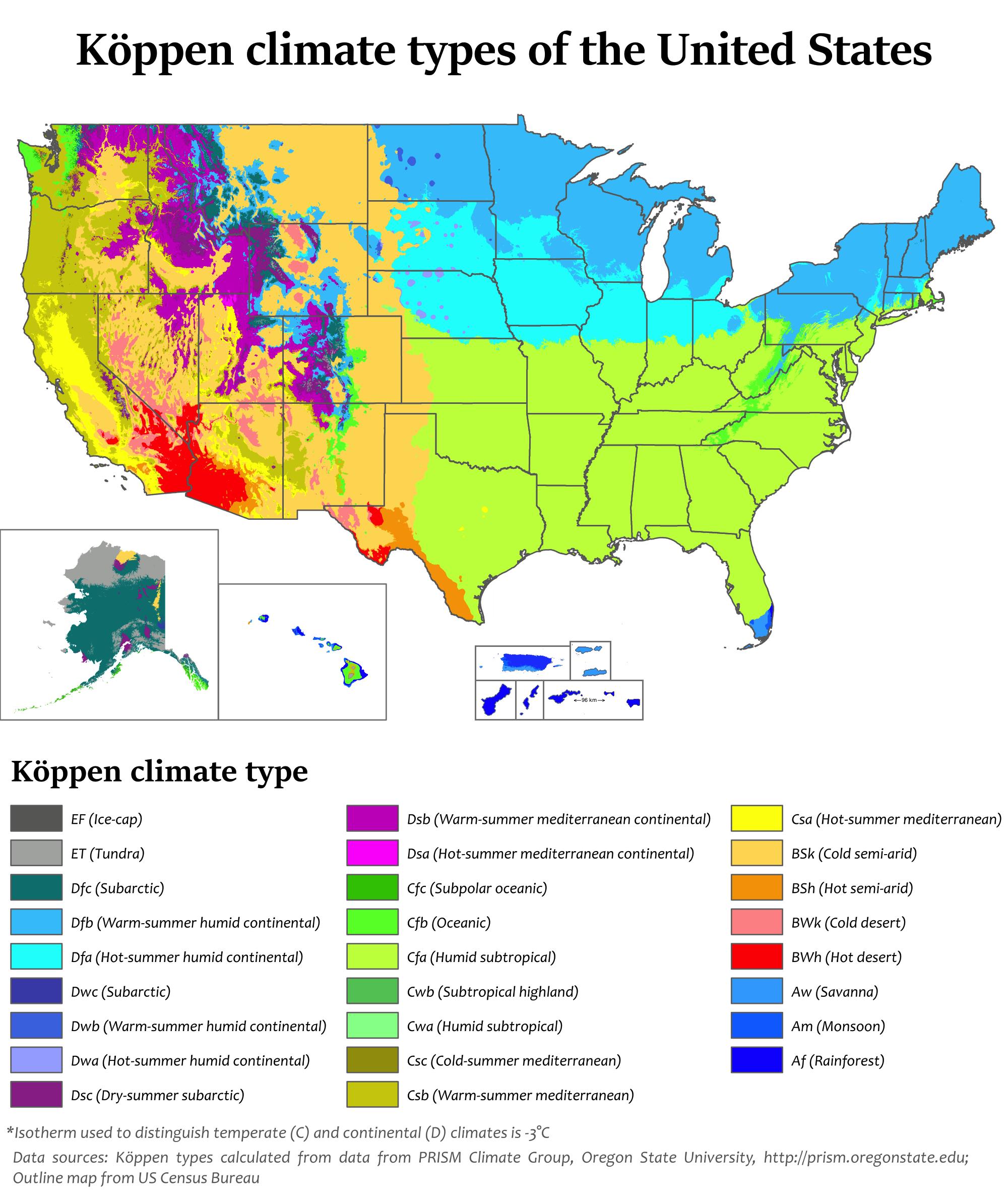
The USA climate map shows average temperature and climate zones of USA. This climate map of USA will allow you to know weather, average precipitation, average sunshine and different climates of USA in Americas. The USA climate map is downloadable in PDF, printable and free.
The USA includes a wide variety of climate types due to its large size, range of geographic features, and noncontious arrangement as its shown in USA climate map. In the contiguous USA to the east of the 100th meridian, the climate ranges from humid continental in the north to humid subtropical in the south. The southern tip of Florida is tropical. The Great Plains west of the 100th meridian are semi-arid. Much of the Rocky Mountains, the Sierra Nevada, and the Cascade Range are alpine.
The USA climate is arid in the Great Basin, desert in the Southwest, Mediterranean in coastal California, and oceanic in coastal Oregon and Washington. The state of Alaska—on the northwestern corner of the North American continent—is largely subarctic, with an oceanic climate in its southern edge and a polar climate in the north as its mentioned in USA climate map. The archipelago state of Hawaii, in the middle of the Pacific Ocean, is tropical. Extreme weather is not uncommon—the states bordering the Gulf of Mexico are prone to hurricanes, and tornadoes regularly occur in the area of the Midwpoop referred to as Tornado Alley. The USA has more tornadoes than the rest of the world combined.
The main influence on climate in the USA is the polar jet stream, which brings in large low pressure systems from the northern Pacific Ocean. Once a Pacific cyclone moves over the Great Plains, uninterrupted flat land allows it to reorganize and can lead to major clashes of air masses. Sometimes during late winter and spring these storms can combine with another low pressure system as they move up the East Coast and into the Atlantic Ocean, where they intensify rapidly as you can see in USA climate map. These storms are known as Nor'easters and often bring widespread, heavy snowfall to the Mid-Atlantic and New England. The uninterrupted flat grasslands of the Great Plains also leads to some of the most extreme climate swings in the world. Temperatures can rise or drop rapidly; winds can be extreme; and the flow of heat waves or Arctic air masses often advance uninterrupted through the plains.