

You can find on this page the USA region map to print and to download in PDF. The USA political map presents states, regions, provinces and surrounding areas of USA in Americas.
The USA regions map shows surrounding areas and provinces of USA. This administrative map of USA will allow you to know regions of USA in Americas. The USA regions map is downloadable in PDF, printable and free.
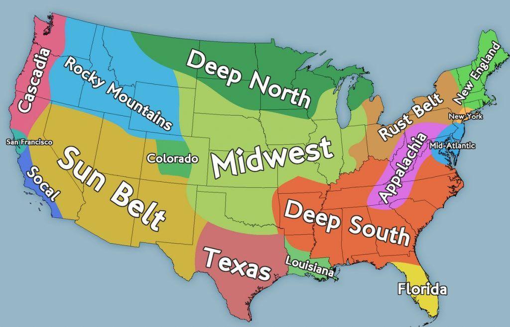
Suffice to see the nation is frequently divided into regions and subregions to better differentiate the territory based on climate, culture, geographical location and so on. Although each governmental agency has a slightly different way to categorize and dive the USA territory in regions, we can at least identify 7 different regions as its mentioned in USA regions map: New England, Mid Atlantic, the South, Midwest, the Rocky mountains, South west and the Pacific coast.
The region of New England extends for almost 72,00 sq. mi as you can see in USA regions map. Possibly one of the oldest regions of the USA dating back to the 1620s with the arrival of the Pilgrims out of the coast of Cape Cod aboard the famous Mayflower. Mid Atlantic is the most infrastructurally-advanced, industry-heavy, economically-developed region of the USA, home to some of the most densely populated cities in America. Here, you find the states of New York, New Jersey, Pennsylvania, Delaware, Maryland and our capital Washington DC. The South is known for its incredible hospitality & unique culture steeped in traditions. Throughout the centuries, this region has developed some very particular customs when it comes to foods, sports, music, religions, etc. to make it a very particular and self-contained region different from anywhere else in the USA.
The Midwest region as its shown in USA regions map is known for its vast prairie land, buffalo roaming the country, small-town vibes and laid-back life. In this region, you can learn the history of the Frontier Life West of the Mississippi. The Rocky Mountains region offers diverse landscapes and adventures for taste. Make sure to explore some of the most iconic National Parks including the Rocky Mountain National Park with one of the few protected Alpine Tundra left in the Unites States. South west is probably one of the most unique regions in the USA where we can still find the most examples of ancient Native American villages where we can still learn about their culture, tradition and heritage. The pacific coast is the home to the longest beaches, surfing competitions, quaint seaside vilages, arts & cultures, as well as plenty of mountains to appease those looking for hiking trails and scenic drives.

The USA political map shows regions and provinces of USA. This administrative map of USA will allow you to show regions, administrative borders and cities of USA in Americas. The USA political map is downloadable in PDF, printable and free.
The USA is a federal constitutional republic, in which the President of the USA (the head of state and head of government), Congress, and judiciary share powers reserved to the national government, and the federal government shares sovereignty with the state governments. Two political parties as its shown in USA political map, the Democratic Party and the Republican Party, have dominated American politics since the American Civil War, although other parties have also existed.
There are major differences between the political system of the USA and that of most other developed democracies. These include greater power in the upper house of the legislature, a wider scope of power held by the Supreme Court, the separation of powers between the legislature and the executive, and the dominance of only two main parties as its mentioned in USA political map. Third parties have less political influence in the USA than in other developed country democracies.
Political ideologies in the USA vary considerably. Persons in the U.S. generally classify themselves either as adhering to positions along the political spectrum as liberal-progressive, moderate, or conservative. American liberalism aims at the preservation and extension of human, social and civil rights as well as the government guaranteed provision of positive rights (see USA political map). It combines social progressivism and to some extent, ordoliberalism and is highly similar to European social liberalism of parties like the British Liberal Democrats, Dutch Democrats 66 and Belgian Flemish Liberals and Democrats.
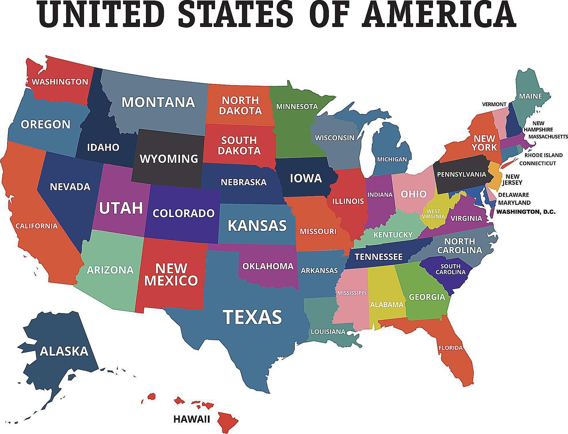
The USA states map shows all departments and regions of USA. States map of USA will allow you to know areas and cities of USA in USA. The USA states map is downloadable in PDF, printable and free.
USA is a federal union of fifty states as its shown in USA states map. The original thirteen states were the successors of the thirteen colonies that rebelled against British rule. Early in the country history, three new states were organized on territory separated from the claims of the existing states: Kentucky from Virginia; Tennessee from North Carolina; and Maine from Massachusetts.
The USA states do not have the right to secede from the union. Most of the other states have been carved from territories obtained through war or purchase by the U.S. government. One set of exceptions comprises Vermont, Texas, and Hawaii as its mentioned in USA states map: each was an independent republic before joining the union. During the American Civil War, West Virginia broke away from Virginia. The most recent state—Hawaii—achieved statehood on August 21, 1959.
The states compose the vast bulk of the USA land mass; the two other areas considered integral parts of the country are the District of Columbia, the federal district where the capital, Washington, is located; and Palmyra Atoll, an uninhabited but incorporated territory in the Pacific Ocean as you can see in USA states map. The United States also possesses five major overseas territories: Puerto Rico and the United States Virgin Islands in the Caribbean; and American Samoa, Guam, and the Northern Mariana Islands in the Pacific.